Outside in Carter County Tennessee
Photos | Resources | Weather | Home | Roan Mountain | Elizabethton | Scots-Irish | Watauga Lake | Waterfalls | Virtual Hike | Wildflowers | Wallpaper | About/Contact
Trail Hiking in Elizabethton and Carter County Tennessee
 Opportunities
for hiking in this area are numerous and varied. From level paved
walkways to technical rock climbing, there's something for every walker,
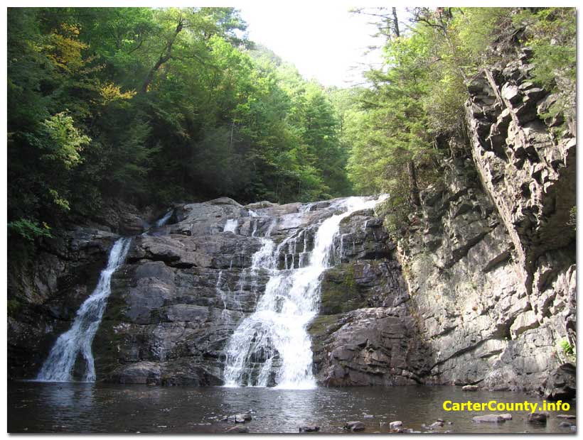
hiker, biker and climber. Some of the local scenic spots, like Laurel
Falls, require walking to reach. The more popular trails are not
extremely difficult and are enjoyed by many people. For an example, try
our virtual hike pages.
Two well known trail systems winding through Carter County are the Appalachian Trail and the Overmountain Victory Trail.
Opportunities
for hiking in this area are numerous and varied. From level paved
walkways to technical rock climbing, there's something for every walker,
hiker, biker and climber. Some of the local scenic spots, like Laurel
Falls, require walking to reach. The more popular trails are not
extremely difficult and are enjoyed by many people. For an example, try
our virtual hike pages.
Two well known trail systems winding through Carter County are the Appalachian Trail and the Overmountain Victory Trail.
The altitude of Carter County ranges from approximately 1500 to 6000 feet (450 to 1800 meters). The terrain is typical of the southern Appalachian mountains. From high old peaks the land opens downward into hollows, coves, and river valleys. The city of Elizabethton is laid out along the Watauga River valley, which accounts for it's elongated shape. The western parts of the county are more open and consist of rolling hills with a sprinkling of houses, cattle and horses. Parts of Johnson City lie within Carter County.
The plant and animal life here is diverse. On the high ridges of Roan Mountain an ancient Canadian type fir-spruce forest survives as an isolated ecosystem. At lower elevations the forest is mostly a mix of conifers and hardwoods. The spring and summer months bring a dazzling display of wildflowers. The fall months are truly a delight. The summer haze and heat fade away leaving many bright sunny afternoons. As the hundreds of species of trees and deciduous plants lose the green of summer the scenery becomes a swirl of fall colors. This happens around the middle to end of October. It varies with altitude and reverses the green march of spring back toward the lower elevations. For a few days at peak time the colors are very intense. Winter offers great benefits for the well prepared hiker. No bugs, weeds or snakes. In some places winter is the only time the underbrush is clear enough to allow easy access. Winter weather can be quite severe at times so plan as if your life depended on it. Skiing cross country is another winter option when the snow is out.
Commonly seen wildlife includes deer, wild turkey and ruffed grouse. Black bears are present but usually avoid people. Part of the local Cherokee National Forest is bear sanctuary. Bobcats live in the area along with coyotes and foxes. There is some debate about the existence of the eastern panther, the red wolf, and other large predators in the Appalachians. We know a reliable witness who spotted a large dog sized cat flicking a long tail at 3 AM near Sam's Gap along I-26 a mile into Tennessee. Stories and sightings abound but little evidence has been documented. Mountain lions have been documented in west Tennessee.
 A wide range of migratory
and full time birds can be seen including bald eagles. The numerous
bodies of water support many types of waterfowl while the forest harbors
a large array of woodland birds. This part of the world has an abundance
of butterflies and dragonflies. Wet places in the mountains are home to
rare species of amphibians and reptiles. Local waterways contain
endangered species of both plants and animals.
A wide range of migratory
and full time birds can be seen including bald eagles. The numerous
bodies of water support many types of waterfowl while the forest harbors
a large array of woodland birds. This part of the world has an abundance
of butterflies and dragonflies. Wet places in the mountains are home to
rare species of amphibians and reptiles. Local waterways contain
endangered species of both plants and animals.
Copperheads and eastern timber rattlesnakes are not often seen but they do exist. Rattlesnakes might give you a warning if you are lucky. The fall leaf colored copperheads are less human friendly. In fact, copperheads can be aggressive and may attack rather than moving away. To further confuse life in the forest the common local garter snakes mimic the copperhead with a shiny brown head but their stripes give them away. Black racers, garter snakes and other colorful snakes are seen more often than the venomous ones. Avoid all snakes and pay attention to your surroundings. Don't put your body parts in places you can't see. A high percentage of snake bite victims were consuming alcohol. Most snakebites aren't fatal but the $50,000+ hospital bill might be.
The terrain itself poses a more common hazard to the hiking public than the occasional poisonous snake and the rare problem bear. Almost every year people die in the local mountains, often near water features. Falls from cliffs are common. The currents underneath waterfalls are especially dangerous. Water levels in all local streams and rivers can rise rapidly if a storm occurs upstream. The Watauga River is controlled by TVA and the water release schedule can be found here. Be safe and use your brain. The Carter County Technical Rescue Team has all the work they need.
In town a nice level fitness trail along the Watauga River can be found at Sycamore Shoals. The city of Elizabethton is in the process of developing linear bike/pedestrian walkways along the the Doe River and Watauga River. Some parts are already completed, including a section by the covered bridge downtown. The 10 mile long railroad right of way through Elizabethton was purchased by Johnson City and has been converted to a trail. The Tweetsie Trail enables foot and bike travel from State Line Road south of Elizabethton all the way to Johnson City.
 The
Appalachian
Trail runs the length of the county. Some of the best scenery on
the trail is found right here. The trail crosses Round Bald on the
Roan massif, Yellow Mountain, Hump Mountain, then crosses Hwy 19E
near the Tennessee-North Carolina state line. It climbs and then follows
the ridge of the aptly named White Rock Mountain while traversing some
of the most remote areas in the county. The trail descends into Dennis
Cove, past Laurel
Falls and then across Hwy 321 at the Shook Branch Recreation Area on Watauga Lake. Then
it winds around the west end of Watauga
Lake, crosses Watauga
Dam and heads up the length of Iron Mountain. Numerous other trails connect to
the Appy Trail and it's easy to miss the many forks along the way. The
white blazes on trees and rocks mark the Appy Trail way. Two blazes
indicate a fork in the trail.
The
Appalachian
Trail runs the length of the county. Some of the best scenery on
the trail is found right here. The trail crosses Round Bald on the
Roan massif, Yellow Mountain, Hump Mountain, then crosses Hwy 19E
near the Tennessee-North Carolina state line. It climbs and then follows
the ridge of the aptly named White Rock Mountain while traversing some
of the most remote areas in the county. The trail descends into Dennis
Cove, past Laurel
Falls and then across Hwy 321 at the Shook Branch Recreation Area on Watauga Lake. Then
it winds around the west end of Watauga
Lake, crosses Watauga
Dam and heads up the length of Iron Mountain. Numerous other trails connect to
the Appy Trail and it's easy to miss the many forks along the way. The
white blazes on trees and rocks mark the Appy Trail way. Two blazes
indicate a fork in the trail.
The Overmountain Victory Trail runs through Sycamore Shoals in Elizabethton and intersects with the Appalachian Trail at Yellow Mountain Gap on the North Carolina-Tennessee state line near Roan Mountain. Nice trail shelter facilities are located there. Every year reenactors of the Overmountain Victory Trail Association gather at Sycamore Shoals in Elizabethton where the story of the Overmountain Men is relived by people in authentic period clothing and gear. Many will journey the entire length of the trail from Virginia to South Carolina, following the same schedule as the original Overmountain Men. It's a walk into the past.
The Overmountain Victory Trail can accessed at a beautiful classic Appalachian cove below Yellow Mountain Gap in 693 acre Hampton Creek Cove State Natural Area. It is located about 3 miles from the town of Roan Mountain on Hampton Creek Road. There is a gravel parking lot on the left a short distance after Gray's Chapel. This is an unusual place with gently sloped hiking in a mountain meadow setting. Parts of it are working pasture with livestock. Watch out for the cow pies. Here's a short video.
Trails are often relocated and sometimes designated for special uses. The nearest US Forest Service office is in Unicoi County (423) 735-1500 and they should have local trail information. Online topographic maps can be viewed at Topoquest though the trail info on these maps is old. For the latest info and maps of the Appalachian Trail check the official AT site.
Here are a couple video clips of Laurel Fork and Laurel Falls. They are also found along with many photos on our virtual hike pages.
Photos | Resources | Weather | Home | Roan Mountain | Elizabethton | Scots-Irish | Watauga Lake | Waterfalls | Virtual Hike | Wildflowers | Wallpaper | About/Contact
Copyright © CarterCounty.info